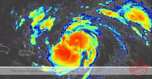
Hurricane Erin strengthened into a powerful Category 5 storm on Saturday only a day after becoming a hurricane. It’s forecast to continue to intensify for at least several hours.
NOAA Hurricane Hunters found maximum sustained winds have increased to nearly 160 mph during a pass through the storm just after 11 a.m. Saturday morning, according to the National Hurricane Center. A Category 5 hurricane has maximum sustained wind speeds of 157 mph or higher.
By Saturday evening, winds around Erin are forecast to reach 165 mph.
The storm joins last year’s Hurricane Milton as one of the fastest intensifying Atlantic hurricanes. Like Erin, Milton also went from a Category 1 to a Category 5 storm in around 24 hours before making landfall as a Category 3 in Siesta Key in October.
Erin’s arrival earlier in the season makes it unique by comparison. The steep drop in the storm’s central pressure over the last 24 hours makes it the “fastest deepening Atlantic hurricane” before September, beating Hurricane Emily’s 2005 record, according to Sam Lillo, a meteorologist and software engineer for DTN Weather.
Most of Erin’s intensification occurred during a 12- to 15-hour window overnight, according to Dan Pydynowski, a meteorologist at AccuWeather. By 5 p.m. Friday, Erin’s winds remained only 75 mph.
The hurricane “had all of the ingredients” necessary to rapidly intensify, Pydynowski said.
Erin has continued moving westward into increasingly warm waters and it faces little to no wind shear, which tears apart storms. The dry air that hindered it earlier this week has moved away, and it’s far enough northeast of the Caribbean islands that there are no land masses interfering with its circulation.
As it continues to track to the west, Erin will continue to be in conditions favorable for intensification, including warm ocean waters and low sheer. However, forecasters do expect the storm’s intensity to “level out” soon, according to National Hurricane Center Director Mike Brennan. A secondary eyewall has begun to form, indicating that the intensity will stabilize while the storm grows bigger in size.
“We expect to see Erin peak here in intensity relatively soon,” Brennan said in an update late Saturday morning.
Erin’s center is forecast to move just north of the islands in the far eastern Caribbean, the Virgin Islands and Puerto Rico into Sunday, the hurricane center said.
The threat to the U.S. East Coast has diminished with each forecast as a sharp turn to the north and eventually northeast is forecast to happen over the next several days, steering Erin well clear of the mainland.
South Florida beachgoers are being warned of life-threatening rip currents that are expected along the coastline early next week, as part of the impacts from Erin.
“While the threat of direct impacts in the Bahamas and along the east coast of the United States appears to be gradually decreasing, there will still be a significant risk of dangerous surf and rip currents along western Atlantic beaches next week,” the hurricane center said.
Several islands along the northeast border of the Caribbean Sea are under tropical storm watches, meaning tropical storm conditions could arrive within 12 hours.
Erin is expected to bring heavy rainfall up to 6 inches through Sunday in areas of the Leeward Islands, the U.S. and British Virgin Islands and southern and eastern Puerto Rico, the hurricane center said Thursday afternoon.
The hurricane center’s cone of uncertainty was just north of the Dominican Republic and Puerto Rico, according to the center’s Saturday morning update. Tropical-storm-force winds could arrive at the island as early as 8 p.m. Saturday. High winds could spur power outages.
As of 2 p.m. Saturday, Erin was 205 miles east-northeast of Puerto Rico, moving west at 16 mph, a slow-down from earlier in the morning. Erin’s tropical-storm-force winds extend up to 140 miles from the center while hurricane-force winds extend up to 30 miles.


