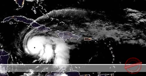
Kingston, Jamaica — Hurricane Melissa intensified to Category 5 early Monday as it neared Jamaica, threatening to bring catastrophic flooding, landslides and widespread damage to homes and infrastructure. The storm is forecast to dump up to 30 inches of rain on Jamaica, along with life-threatening storm surge along its southern coast.
Melissa is expected to make landfall on the island Monday night and Tuesday and cross southeastern Cuba and the Bahamas through Wednesday.
On Monday afternoon, the hurricane had maximum sustained winds of 175 mph and was inching west at a slow pace, just 3 mph, the center said.
Category 5 is the highest on the Saffir-Simpson scale, for storms with sustained winds of at least 157 mph — catastrophic strength capable of destroying many of the homes in its path.
“Destructive winds and storm surge and catastrophic flooding will worsen on Jamaica through the day and into tonight,” CBS News meteorologist Nikki Nolan stressed.
Melissa is expected to be the most powerful storm to ever hit Jamaica, and, potentially, the most powerful storm on record to ever make landfall anywhere, CBS News Philadelphia meteorologist Grant Gilmore said on Monday. The storm’s slow pace, which it was forecast to maintain while traversing Jamaica, increased the likelihood that it would bring “profound” devastation to the island, according to Gilmore.
“All of the threats that a hurricane can unleash on an island, it’s all going to happen in Jamaica over the next 36 hours,” he said.
In Jamaica, mandatory evacuations were ordered in seven flood-prone communities, where buses carried people to shelters, according to the Office of Disaster Preparedness and Emergency Management there.
In addition to the impact on Jamaica, western Haiti could get 16 inches of rain, bringing the threat of catastrophic flash flooding and landslides there too, the hurricane center warned.


