After a fairly mild Monday, the active weather is picking up across Colorado on Tuesday.
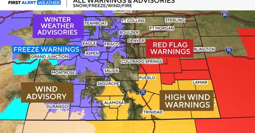
The mountains are littered with Winter alerts, and southeast Colorado is under the threat of high fire danger going into Tuesday afternoon.
Winter Weather Advisories, Freeze Warnings, Avalanche Warnings, Wind Advisories, Red Flag Warnings, and High Wind Warnings all cover parts of the state.
The mountains will continue to see snow throughout Tuesday, falling heavily at times.
Snow totals in some mountain areas could reach up to 12″. Along with the new snow come some stronger wind gusts, which could cause some visibility concerns heading into the afternoon hours on Tuesday.
The Front Range will see increasing cloud cover throughout the afternoon, with a chance of rain and possibly a few storms later on Tuesday afternoon.
Southeastern Colorado will stay dry and windy this afternoon.
Red Flag Warnings and High Wind Warnings are in place as winds could gust up to 65 mph.
The down-sloping winds will also bring some gusty conditions to the Denver metro area at times on Tuesday.
The remainder of the week will stay on the active side with snow chances for the Denver area on Thursday, lingering through Saturday


